Maps & Driving Directions
Whether this is your first time traveling to Puerto Penasco aka Rocky Point, Mexico or you have been there before here you will find several very helpful maps. From detailed driving directions from several cities in the US to city maps of Puerto Penasco including resort locations, restaurants, beaches, driving distances and more.
From Phoenix, AZ – East Valley
Distance 212 miles / 345 kilometers
1. Take Loop 202 or SR60 (Superstition Freeway) to I-10 South
2. Exit on SR 347 (exit 164) and head towards Maricopa
3. Continue on SR 347 through Maricopa until you reach SR 238 towards Mobile (also known as Dead Cow Road)
4. SR 238 will end at a STOP sign. Turn left at the STOP sign and it will put you into Gila Bend.
5. Continue through Gila Bend until you reach McDonald’s. Turn right at the sign just before the McDonald’s for Mexico/SR 85 South.
6. Take SR 85 South to Ajo (39 miles)
7. Continue on SR 85 South to Why, AZ (10 miles)
8. Continue on SR 85 South to Lukeville, AZ (27 miles)
9. Lukeville is the border between USA and Mexico. Once you cross the boder, you will be in Sonoyta, Mexico. At this time, distances change from miles to kilometers.
10. Continue on the main road for approximately 1.8miles. You will arrive at a 2-way intersection with a stop sign. At this time, you will see a monument and signs for Puerto Penasco and Santa Ana to
the left. Make a left at the stop sign and then bear right, follow thesigns to Puerto Penasco.
11. Stay to the right towards Puerto Penasco/Caborca at the Y on the road. There is a traffic light soon after you bear right. Continue straight through this traffic light to Mexico Highway 8.
12. Once you have gone through Sonoyta, continue on Highway 8 from Sonoyta to Puerto Penasco (60 miles). Continue on Highway 8 until you see the sign for your appropriate resort. For all Sandy Beach Resorts (Sonoran Sea, Princesa, Las Palomas, Las Palmas, Bella Sirena, Sonoran Spa, Sonoran Sun, Esmeralda, Casa Blance) you will turn at the first light when you reach town. This light will have signs for Sandy Beach Resorts and it is named Blvd. Samuel Ocana.
13. If you turn to go to Sandy Beach Resorts, continue on Samuel Ocana past the railroad tracks. You will reach a round-about with a Circle K. Continue on the road and head towards the resorts on the horizon through the arches at Costa Diamante.
From Phoenix, AZ – West Valley
Distance 212 miles / 345 kilometers
1. Take I-10W to Buckeye
2. Exit State Route 85 South and continue to Gila Bend/I-8 San Diego
3. After reaching Gila bend, continue until you reach McDonalds. Turn right just before McDonalds at the sign for Mexico/SR 85 South.
4. Take SR 85 South to Ajo (39 miles)
5. Continue on SR 85 South to Why, AZ (10 miles)
6. Continue on SR 85 South to Lukeville, AZ (27 miles)
7. Lukeville is the border between USA and Mexico. Once you cross the boder, you will be in Sonoyta, Mexico. At this time, distances change from miles to kilometers.
8. Continue on the main road for approximately 1.8miles. You will arrive at a 2-way intersection with a stop sign. At this time, you will see a monument and signs for PTO Penasco and Santa Ana to the left. Make a left at the stop sign and then bear right, follow the signs to Puerto Penasco.
9. Stay to the right towards Puerto Penasco/Caborca at the Y on the road. There is a traffic light soon after you bear right.
10. Continue straight through this traffic light to Mexico Highway 8.
11. Once you have gone through Sonoyta, continue on Highway 8 from Sonoyta to Puerto Penasco (60 miles). Continue on Highway 8 until you see the sign for your appropriate resort. For all Sandy Beach Resorts (Sonoran Sea, Princesa, Las Palomas, Las Palmas, Bella Sirena, Sonoran Spa,
Sonoran Sun, Esmeralda, Casa Blance) you will turn at the first light when you reach town. This light will have signs for Sandy Beach Resorts and it is named Blvd. Samuel Ocana.
12. If you turn to go to Sandy Beach Resorts, continue on Samuel Ocana past the railroad tracks. You will reach a round-about with a Circle K. Continue on the road and head towards the resorts on the horizon through the arches at Costa Diamante.
From Tucson, AZ
Distance: 212 miles / 345 kilometers
1. Take I-10 to I-19 South
2. After approximately 1 mile, exit onto SR 86 West (Ajo Highway)
3. Continue on SR 86 West until you arrive at the intersection of SR 85 in Why, Az.
4. Turn left (south) on SR 85
5. Continue on SR 85 South to Lukeville, AZ until you reach the US/Mexico border. (30 miles)
6. Lukeville is the border between USA and Mexico. Once you cross the boder, you will be in Sonoyta, Mexico. At this time, distances change from miles to kilometers.
7. Continue on the main road for approximately 1.8miles. You will arrive at a 2-way intersection with a stop sign. At this time, you will see a monument and signs for PTO Penasco and Santa Ana to the left. Make a left at the stop sign and the bear right, follow the signs to Puerto Penasco.
8. Stay to the right towards Puerto Penasco/Caborca at the Y on the road. There is a traffic light soon after you bear right. Continue straight through this traffic light to Mexico Highway 8.
9. Once you have gone through Sonoyta, continue on Highway 8 from Sonoyta to Puerto Penasco (60 miles). Continue on Highway 8 until you see the sign for your appropriate resort. For all Sandy Beach Resorts (Sonoran Sea, Princesa, Las Palomas, Las Palmas, Bella Sirena, Sonoran Spa, Sonoran Sun, Esmeralda, Casa Blance) you will turn at the first light when you reach town. This light will have signs for Sandy Beach Resorts and it is named Blvd. Samuel Ocana.
10. If you turn to go to Sandy Beach Resorts, continue on Samuel Ocana past the railroad tracks. You will reach a round-about with a Circle K. Continue on the road and head towards the resorts on the horizon through the arches at Costa Diamante.
There are 2 routes you can take to get to Puerto Penasco from Southern California. The first route has you driving on Mexican roads for about half your trip but it’s a shorter route. The second option only has you driving in Mexico for about 60 miles but it can add about 100 miles to your trip depending on where you’re coming from.
From Southern California – San Diego, CA / Yuma, AZ via El Golfo de Santa Clara
Distance 327 miles / 516 kilometers
Note: The following route shows directions crossing the border in Yuma, AZ which has you driving in Mexico for about half of your trip via El Golfo de Santa Clara.
From Southern California take highway 8 to Yuma, Az
Take highway 95 from Yuma to San Luis, AZ
Cross the border in San Luis, Az/San Luis Rio Colorado Mexico
In Mexico take highway SON 3 to El Golfo de Santa Clara all the way to Puerto Peñasco
Second Option crossing the border in Lukeville, AZ
Distance 421 miles / 677 kilometers
1. Take I-8 East from Southern California or Yuma, Arizona
2. Take SR 85 exit to Gila Bend
3. Continue through Gila Bend until you reach McDonalds. Turn right at the sign just before the McDonalds for Mexico/SR 85 South.
4. Take SR 85 South to Ajo (39 miles)
5. Continue on SR 85 South to Why, AZ (10 miles)
6. Continue on SR 85 South to Lukeville, AZ (27 miles)
7. Lukeville is the border between USA and Mexico. Once you cross the boder, you will be in Sonoyta, Mexico. At this time, distances change from miles to kilometers.
8. Continue on the main road for approximately 1.8miles. You will arrive at a 2-way intersection with a stop sign. At this time, you will see a monument and signs for PTO Penasco and Santa Ana to
the left. Make a left at the stop sign and the bear right, follow the
signs to PTO Penasco.
9. Stay to the right towards Puerto Penasco/Caborca at the Y on the road. There is a traffic light soon after you bear right. Continue straight through this traffic light to Mexico Highway 8.
10. Once you have gone through Sonoyta, continue on Highway 8 from Sonoyta to Puerto Penasco (60 miles). Continue on Highway 8 until you see the sign for your appropriate resort. For all Sandy Beach Resorts (Sonoran Sea, Princesa, Las Palomas, Las Palmas, Bella Sirena, Sonoran Spa, Sonoran Sun, Esmeralda, Casa Blance) you will turn at the first light when you reach town. This light will have signs for Sandy Beach Resorts and it is named Blvd. Samuel Ocana.
11. If you turn to go to Sandy Beach Resorts, continue on Samuel Ocana past the railroad tracks. You will reach a round-about with a Circle K. Continue on the road and head towards the resorts on the horizon through the arches at Costa Diamante.
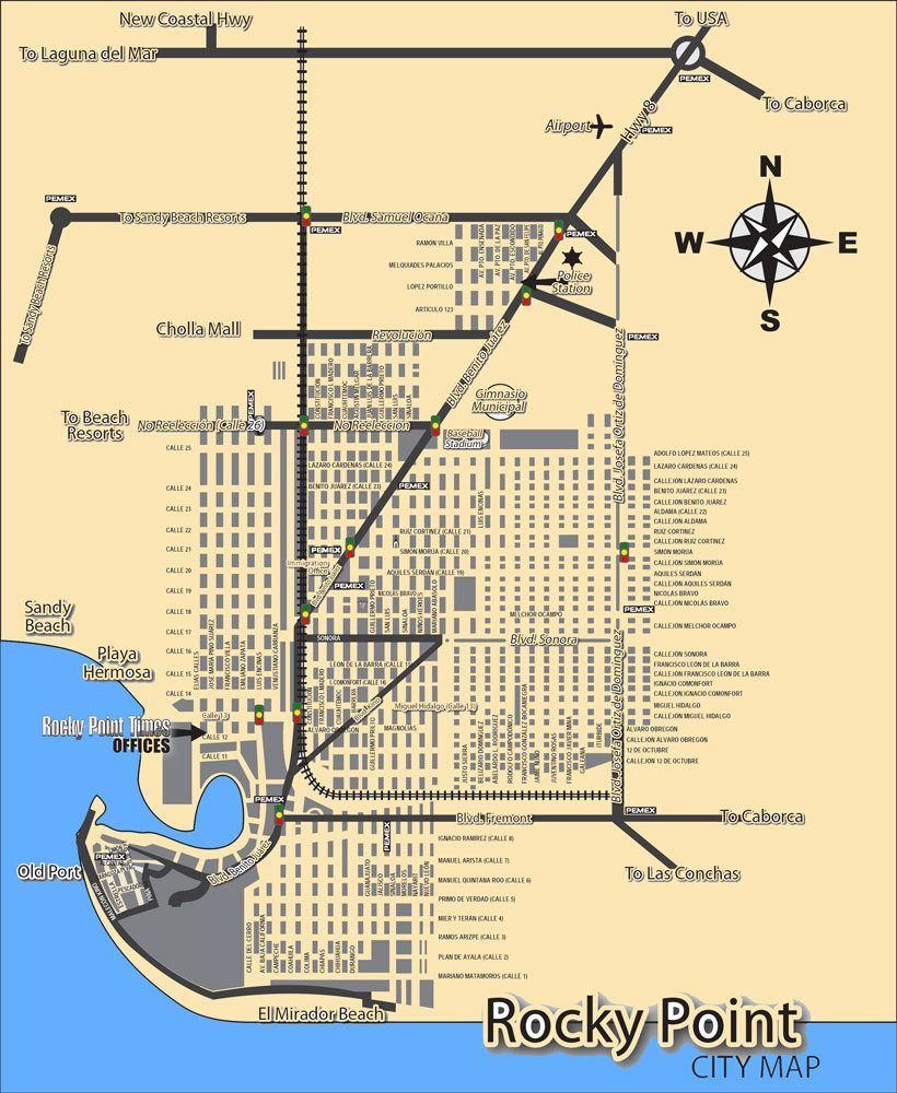
The following maps offer helpful city maps of Puerto Penasco (Rocky Point) published by the Rocky Point Times. The first city map includes all major street and surface street names. It also shows the locations of most gas stations, police station, beach areas, directions to Sandy beach resorts and the Old Port. You can click on the map to see a larger version of it or for a very detailed printable pdf map version please click here.
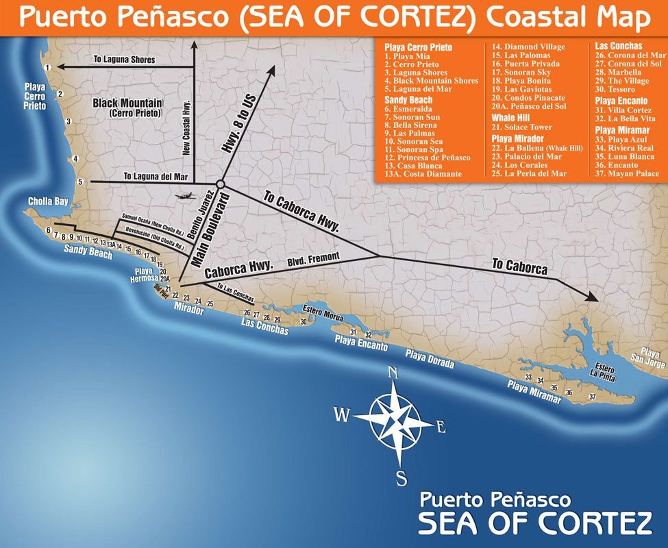
The second map shows you a more detailed version of the coastal Rocky Point area. Here you will see all the resort locations and names in all the different Puerto Penasco beach areas. You can click on map to see larger version or for detailed printable pdf map please click here.
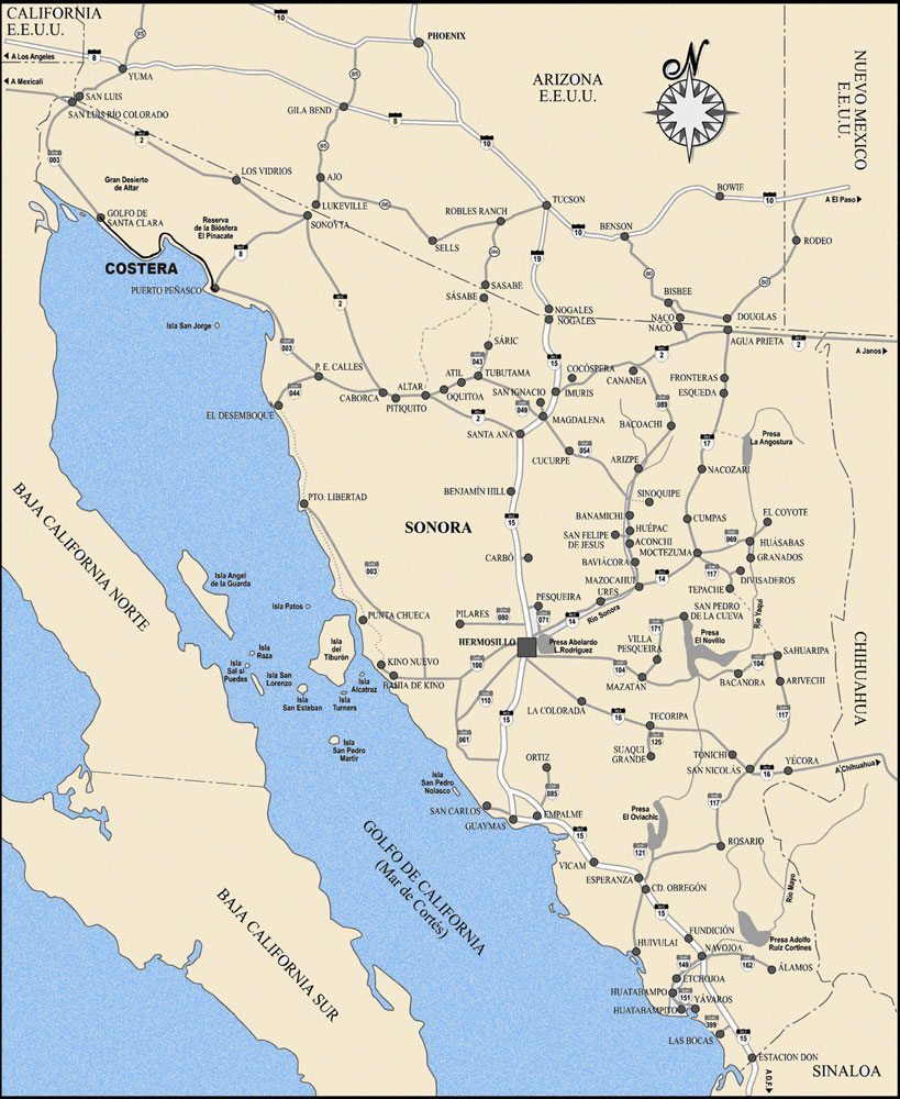
The third map is the state of Sonora. The map shows you the state main highways as well as the surrounding beach towns and near by islands. You can click on map to see larger version or for detailed printable pdf map please click here.
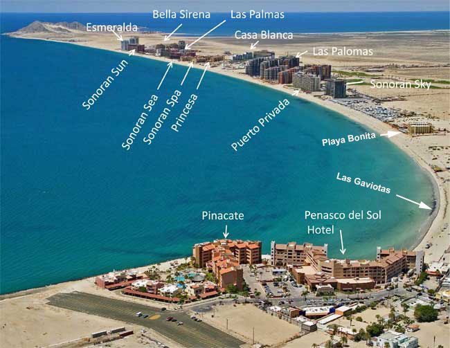
The fourth map is a photographic map of Sandy beach showing the resorts located on this beautiful Rocky Point beach area. Click on image for larger view.
This google map shows the location of restaurants and bars in Rocky Point. If you click on the map you will see the google reviews for the restaurants listed but for a more accurate restaurant rating visit our restaurants page which offers a more detailed list of restaurants rated by tripadvisor.
This google map shows the location of all Puerto Penasco resorts and hotels we serve. Please visit our Resorts page for detailed information and rates about each resort as well as any available specials and discounts.